

1.2 - Terrestrial Biomes
Learning Objectives
The primary goal here is describing the global distribution and specific environmental conditions of land based (terrestrial) biomes. We also need to understand how the plants and animals that live in a biome are adapted to its climate. The associated skill is explaining an environmental concept or process.
Defining Biomes and Climate
A biome is a large geographical area defined by a shared combination of environmental factors. Those factors make up its climate, which is the combination of average yearly temperature and precipitation trends. Climate is the major force determining which organisms can survive there.
For example, a tropical rainforest is defined by consistently high rainfall and warm temperatures. A desert, by contrast, is mainly distinguished by very low precipitation, though it may also have high temperatures.
Organism Adaptation
The organisms in a biome’s community have to be uniquely adapted to endure its specific climate conditions.
Organism | Adaptation Example | Survival Purpose |
Camels (desert) | Store energy as fat in their humps. A thick coat of fur blocks the sun's heat, and they lose very little water in their urine and feces. | Energy reserve for long periods without food, plus less heat taken in and less water lost. |
Shrubs and wildflowers (fire prone biomes) | Long, deep roots. | Store large amounts of energy deep underground, which lets them regrow quickly after devastating wildfires. |
Distribution of Biomes
Temperature and precipitation are the two most important characteristics, and they’re the defining characteristics of a biome. The range of these characteristics also predicts where biomes show up on Earth’s surface. Distance from the equator heavily influences these patterns.
- Tropical biomes (tropical rainforests, savannas / tropical seasonal forests) are concentrated around the equator. This region gets the most direct sunlight, which produces consistently warm temperatures. Rainforests get heavy rain all year, while savannas and tropical seasonal forests have a long dry season.
- Temperate biomes (temperate seasonal forests, temperate grasslands) sit in the middle latitudes, between 30 and 60 degrees. They get moderate rainfall and moderate temperatures, with reasonably warm summers and somewhat cool winters.
- Colder and drier biomes (tundra, boreal forest) are farther from the equator, concentrated around 60 degrees latitude or higher. These areas have low precipitation and colder conditions.
- Deserts cluster near 30 degrees north and south latitude (the Sahara, the Arabian Desert, the Sonoran Desert, and Australia's deserts). Air that dropped its rain over the equator sinks at about 30 degrees, warms up, and dries out the land below it (see 4.5).
The Nine Major Terrestrial Biomes
These are the nine terrestrial biomes the course expects you to know. For each one, know its climate (temperature and precipitation), where it's found, and how its plants and animals are adapted. The numbers are typical values, and real places vary.
Biome | Climate | Where it's found | Plants, animals, and adaptations |
Tundra | Very cold most of the year, with a growing season of only about 2 months. Dry, often under 25 cm of precipitation a year. | Far north (northern Alaska, Canada, Russia), plus alpine tundra on high mountains. | No trees. Mosses, lichens, grasses, and low shrubs grow close to the ground, out of the wind, with shallow roots above the permafrost. Caribou, arctic foxes, and migrating birds. |
Taiga (boreal forest) | Long, very cold winters and short, cool summers. Moderate precipitation, much of it as snow. | A wide belt across Canada, Alaska, Scandinavia, and Russia. | Conifers like spruce, fir, and pine. Needles with a waxy coating lose little water, the cone shape sheds snow, and staying green lets trees photosynthesize as soon as it warms up. Moose, lynx, wolves. Acidic, nutrient-poor soil. |
Temperate rainforest | Mild, cool temperatures all year with heavy rain and fog. | Coastal areas: the Pacific Northwest (Washington, Oregon, British Columbia), southern Chile, New Zealand. | Giant conifers like Douglas fir, Sitka spruce, and western redcedar, covered in mosses and ferns. The Hoh Rain Forest in Washington's Olympic National Park gets more than 3 m of rain a year. |
Temperate seasonal forest | Four seasons: warm, humid summers and cold winters. Moderate precipitation spread through the year (about 75 to 150 cm). | Eastern United States, much of Europe, eastern China, Japan. | Broadleaf deciduous trees (oak, maple, beech) drop their leaves in fall, so they don't lose water through leaves while the ground is frozen. Fallen leaves make fertile soil. Deer, squirrels, black bears. |
Tropical rainforest | Hot all year (about 25 to 28°C on average, with little change between seasons) and very wet, around 200 cm of rain a year or more. | Near the equator: the Amazon Basin, the Congo Basin in central Africa, Southeast Asia (Indonesia, Malaysia). | The most biodiverse land biome. Plants compete for light in layers up to a tall canopy; big leaves with drip tips shed heavy rain; shallow and buttress roots; epiphytes grow on branches. Nutrient-poor soil, because nutrients are held in the plants and heavy rain leaches the rest away. |
Shrubland (chaparral) | Hot, dry summers and mild, rainy winters (a Mediterranean climate). | Southern California, around the Mediterranean Sea, central Chile, the southwestern tip of South Africa, southwestern Australia. | Shrubs with small, thick, waxy leaves that hold water through the dry summer. Fire is common, and many plants resprout from deep roots or have seeds that sprout after a fire. |
Temperate grassland | Hot summers and cold winters. Not enough rain for most trees, plus droughts and fires. | The Great Plains of North America (prairie), Ukraine and Russia (steppe), Argentina (pampas). | Grasses with deep roots survive drought, fire, and grazing and regrow from below ground. Deep, very fertile soil, which is why most prairie has been turned into farmland. Bison, prairie dogs. |
Savanna | Warm all year, with a long dry season and a rainy season. | East Africa (the Serengeti), plus parts of South America and northern Australia. | Grassland with scattered trees like acacias and baobabs. Grasses grow fast in the rainy season and survive fire and grazing. Huge herds of grazers (zebras, wildebeest, elephants) and predators like lions. Many animals migrate with the rains. |
Desert | Very dry, under about 25 cm of precipitation a year. Can be hot (Sahara) or cold (Gobi), with big temperature swings between day and night. | Mostly near 30° north and south latitude (Sahara, Sonoran, Australian deserts) and in rainshadows. | Cacti and other succulents store water in thick stems, have spines instead of leaves, and have a waxy coating that cuts water loss. Many open their stomata only at night. Kangaroo rats are active at night and get almost all their water from the seeds they eat. Soil has little organic matter. |
Reading a Climatogram
A climatogram (climate diagram) shows a place's average temperature and precipitation for each month of the year. The bars are precipitation (read on the left axis) and the line is temperature (read on the right axis). Exam questions often show one and ask which biome it matches.
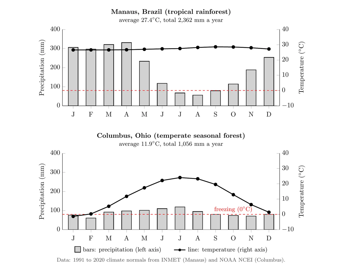
- Check the temperature line. Flat and warm all year means the tropics. A big swing between summer and winter, with months near or below freezing, means a temperate or polar biome.
- Check the yearly total. Under about 25 cm (250 mm) a year is a desert. Around 200 cm (2,000 mm) or more with warm temperatures all year is a tropical rainforest.
- Look for a dry season. Several months with almost no rain point to a savanna (warm all year) or a shrubland (dry summer, wet winter).
Applying it: Manaus, Brazil, averages 27.4°C, and its warmest and coolest months differ by only 2°C. It gets about 236 cm of rain a year, and even its driest month (August) gets 56 mm, so it's a tropical rainforest. Columbus, Ohio, goes from an average of -1.3°C in January to 24.1°C in July and gets about 106 cm of precipitation spread fairly evenly through the year, so it's a temperate seasonal forest.
The Role of Nutrient Availability
Beyond climate, nutrient availability in the soil is a very important characteristic. Soil nutrients are necessary for plant growth, so nutrient levels ultimately determine which plants and how many species can survive in a biome.
The rate of decomposition, meaning how quickly dead organic matter is broken down to recycle nutrients, often dictates nutrient availability, and that rate is strongly influenced by temperature.
Biome | Nutrient Level | Reason |
Tundra | Low | The soil is permanently frozen year round (permafrost). That frozen state limits decomposition of organic matter, so nutrients aren’t recycled effectively. |
Boreal Forest | Nutrient poor | Dominated by coniferous trees like pine and spruce. Low temperatures for much of the year slow down decomposers (fungi, earthworms), which prevents fast nutrient cycling. |
Tropical Rainforest | Quite nutrient poor | Despite massive plant growth, the huge number of plants constantly compete for nutrients, which get absorbed as soon as they become available. |
Temperate Forests | Very high | Broad leaved trees like oaks and maples drop their leaves every fall, providing abundant organic matter. Moderate temperatures allow rapid decomposition, making nutrients readily available in the soil. |
Why Resources Like Water and Timber Aren't Spread Evenly
Nonmineral natural resources, like fresh water and trees for lumber, depend on the same factors that shape biomes. Some combination of these factors makes a region rich or poor in a resource:
- Climate: trees need enough rain and a long enough growing season. The big timber regions are wet forests, like the boreal forests of Canada and Russia and the temperate forests of the Pacific Northwest and the southeastern US.
- Latitude: sunlight and temperature drop as you move away from the equator, so growing seasons get shorter and trees grow more slowly toward the poles.
- Altitude: air cools by about 6.5°C for every 1,000 m you climb, so going up a mountain is like traveling toward the poles. Mount Kilimanjaro in Tanzania sits near the equator but has rainforest on its lower slopes and a cold, rocky, nearly plantless zone near the top.
- Geography: mountains and distance from the ocean control where rain falls. Moist air from the Pacific rises over Washington's Cascade Mountains and drops its rain on the western side, which grows huge Douglas firs, while the eastern side sits in a dry rainshadow (see 4.8).
- Nutrient availability and soil: deep, fertile soil supports fast plant growth, and the type of soil controls how much water soaks in and is stored. Grassland soils in the US Midwest are some of the best farmland in the world, while thin, nutrient-poor tropical soils lose their fertility within a few years of the forest being cleared.
Changing Biome Locations
Biome distribution isn’t static, because Earth’s climate is subject to rapid change, often due to human activities.
- Impact of warming: As the climate warms, the locations of biomes will shift.
- Boreal forest example: The boreal forest is predicted to shift further north. Soils that were previously frozen for most of the year are thawing out, which lets large tree species grow in those northern regions.
- Range loss: At the same time, the boreal forest will likely lose parts of its southern range as those areas become too warm for key species like aspen and spruce.
- Observation: Photographs taken of the same Arctic land plot show the forest boundary slowly creeping northward as global warming makes previously inhospitable soils warmer.
- Biomes have moved before: about 20,000 years ago, at the peak of the last ice age, ice sheets covered almost all of Canada and parts of the northern US, and boreal forest and tundra grew far south of where they are today. Later, from about 11,000 to 5,000 years ago, a wetter climate turned much of the Sahara into grassland with lakes before it dried back into desert.
- Why today's shift is a problem: those past shifts happened over thousands of years. Today's warming is much faster, and many plants (especially slow-growing trees) can't spread their seeds fast enough to keep up, so species can lose their old range before they establish a new one.
Big picture: Thinking about biomes is like zoning a city based on weather regulations. Just as a city zones areas for certain types of buildings based on required rainfall, elevation, and average temperature, latitude and climate are the natural zoning laws that dictate which biomes (the “buildings,” or communities of organisms) are allowed to exist in a given geographic region.