

4.8 - Earth’s Geography and Climate
Learning Objectives
The main objective is to describe how Earth’s geography affects weather and climate. The essential knowledge is that weather and climate are affected by the sun’s energy and also by geographic factors like mountains and ocean temperature. The associated skill is explaining relationships between characteristics of environmental concepts represented visually.
Introduction: Determinants of Regional Climate
Global climate is broadly determined by insolation, meaning solar radiation intensity:
- The equator gets the most direct sunlight, making it the warmest, which drives air to rise and produces the highest precipitation.
- Air sinking from the Hadley cell at 30 degrees North and South creates the world’s very dry conditions and deserts.
But regional climate is determined more precisely by two major geographic factors:
1. The location of mountains, which can disrupt the movement of wind and produce the rainshadow effect.
2. The location and temperature of oceans, which add moisture to the air over nearby land and can moderate or stabilize temperature. Water absorbs heat from the land when it’s hot and releases heat to the land when it’s cold.
The Rainshadow Effect (Mountain Influence)
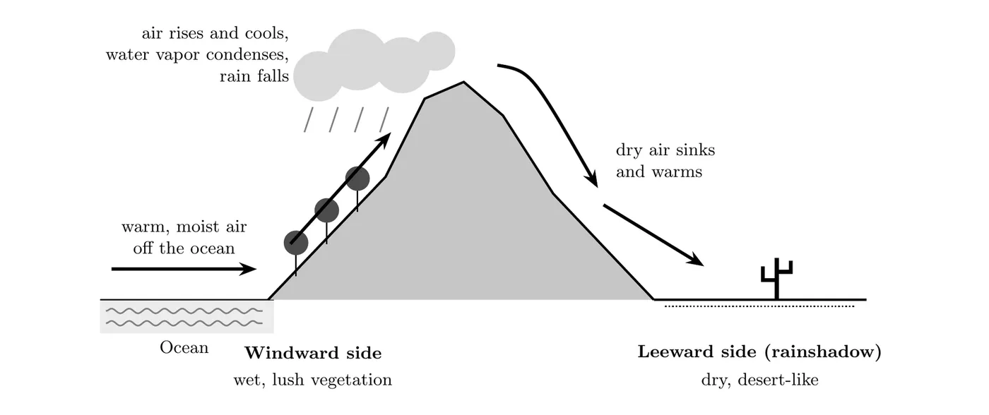
The rainshadow effect describes the different weather patterns on either side of a mountain range. It’s especially pronounced when the mountains are near the coast.
A. Windward Side (Facing the Wind)
- Process: The windward side faces the ocean. A warm, moist airmass blowing off the ocean hits the mountain, and the impact forces the air mass to rise.
- Weather: As the air rises, it cools, and the water vapor inside is forced to condense and fall as rain.
- Result: The windward side gets a lot of rainfall and has lush green vegetation.
B. Leeward Side (Rainshadow)
- Process: The leeward side faces away from the wind. By the time the air descends on this side, it has already dumped most of its moisture on the windward side.
- Weather: The cool, descending airmass is very dry.
- Result: This side forms desert-like conditions.
Real-World Example: The Andes Mountains
The Andes, a long, narrow coastal mountain range in South America, are a clear example of the rainshadow effect:
- Wind Direction: The prevailing winds between and latitude move from east to west.
- Windward Side (East): The eastern side of the Andes faces the wind and gets moist air that picked up water from the Atlantic Ocean. This side has lush green rainforest areas with high precipitation.
- Leeward Side (West): The air descends on the western side as a really dry airmass, which produces the arid desert conditions of the Atacama Desert.
- Combined Factors: The Atacama Desert also sits close to 30 degrees South latitude, so it’s already subject to the dry, sinking air from Hadley cell circulation, which makes the arid conditions even more extreme.
- Cold Ocean Water: The cold Humboldt Current flows north along the coast of Chile and Peru. Cold water chills the air right above it, and cool air sitting under warmer air can’t rise to build rain clouds. That’s a third reason the Atacama is one of the driest places on Earth.
Real-World Example: The Olympic Mountains (Washington State)
Moist air blowing in off the Pacific Ocean hits the west side of the Olympic Mountains and rises. The Hoh Rain Forest on the windward side gets about 140 to 170 inches of rain a year, one of the wettest places in the lower 48 states. On the leeward (northeast) side, the town of Sequim gets only about 16 inches a year, about the same as Los Angeles. Same mountains, same storms, but only about a ninth to a tenth as much rain.
Influence of Local Bodies of Water
Even without a mountain range, local bodies of water can significantly affect regional precipitation.
- Coastal Effects: Prevailing winds moving from the ocean toward the land (the windward direction) pick up moisture from the water. When that warm, moisture-loaded air hits the landmass, it generally dumps more rainfall right along the coast.
- Example (Mexico / Central America): The prevailing winds come from the east, picking up moisture from the Gulf of Mexico and the Atlantic Ocean. So the eastern coast of the region is expected to see more rainfall.
- Oceans Moderate Temperature: Water has a high specific heat, so it heats up and cools down much more slowly than land. Coastal places get milder winters and cooler summers than inland places at the same latitude. Example: San Francisco’s summers are cool and foggy because the cold California Current runs along the coast, while California’s inland valleys bake in summer heat.
- Warm vs. Cold Currents: Warm currents warm the air and add moisture (the Gulf Stream helps keep western Europe mild, 4.9). Cold currents cool the air and keep it from rising, so coasts next to them tend to be cool and dry, like the Atacama (Humboldt Current) and the Namib Desert in southern Africa (Benguela Current).
- Lake-Effect Snow: In late fall and winter, cold, dry air blowing across the Great Lakes picks up heat and moisture from the still-warmer water, rises, and dumps heavy snow on the downwind shore. Buffalo, New York, at the east end of Lake Erie, regularly gets buried this way, since the westerlies blow across the lake toward it.
Elevation and Temperature
Mountains also change climate just by being high. Air gets colder as you go up, about 6.5°C for every 1,000 m on average (4.4). That’s why mountain peaks can be snowy while the valleys below are warm, and why climbing a tall mountain is like traveling toward the poles: you pass through different biomes on the way up.
Practice calculation: A valley at 500 m elevation is 24°C. About how warm is a peak at 3,500 m?
Big picture
The rainshadow effect is basically a mountain acting as a giant physical air purifier. As moist air travels up the windward side, the mountain forces it to wring out all its water vapor as rain, giving that side a massive drink. By the time the air passes over the ridge and descends on the leeward side, it’s been purified and is completely dry, which creates that stark predictable contrast of a lush forest on one side and a dry desert on the other.