

4.9 - El Niño and La Niña
Learning Objectives
The main objective is to describe the environmental changes and effects of El Niño and La Niña events. These events involve significant changes in Pacific ocean surface temperature, global wind patterns, and ocean currents. The associated skill is describing environmental problems.
I. Global Ocean Circulation Systems (Background)
A. Gyres and Surface Currents
A gyre is a large ocean circulation pattern driven by global wind patterns.
- Rotation: Gyres rotate clockwise in the Northern Hemisphere and counterclockwise in the Southern Hemisphere.
- Driving Winds: Surface waters get moved from east to west along the equator (0° to 30°) by the trade winds, then switch to moving from west to east between 30° and 60° because of the westerlies.
B. Thermohaline Circulation (Deep Ocean Mixing)
Thermohaline circulation is a movement of ocean currents that connects all the world’s oceans and mixes salt, nutrients, and temperature.
- Process: Warm surface water, like the Gulf Stream, moves north, where some of it evaporates, leaving the remaining water saltier (sea ice forming in winter also leaves its salt behind). That water also cools, which makes it denser both from lower temperature and higher salt content. This dense water sinks to the ocean floor in the North Atlantic, near Greenland and Iceland, then creeps along the bottom through the world’s oceans.
- Climate Moderation: This circulation matters for moderating temperature, since the warm current deposits heat over areas like Europe, making their climate far warmer and more moderate than other regions at the same latitude, like Canada.
C. Upwelling (Normal Condition)
Upwelling is a critical process where warm surface waters move away from a landmass, like the coast of the Americas, and colder, deeper water rises up to replace it.
- Benefits: Upwelling increases productivity because: 1. It brings up nutrients (like nitrates and phosphates) from deep water, where dead organisms sank and decomposed. These nutrients feed phytoplankton, the base of the food web. This is the main reason. 2. Cold water can hold more dissolved oxygen than warm water.
- Result: Along these upwelling zones, especially off the coast of the Americas, there are really productive fisheries where people depend on catching fish for food and income.
II. Normal (Neutral) Pacific Conditions
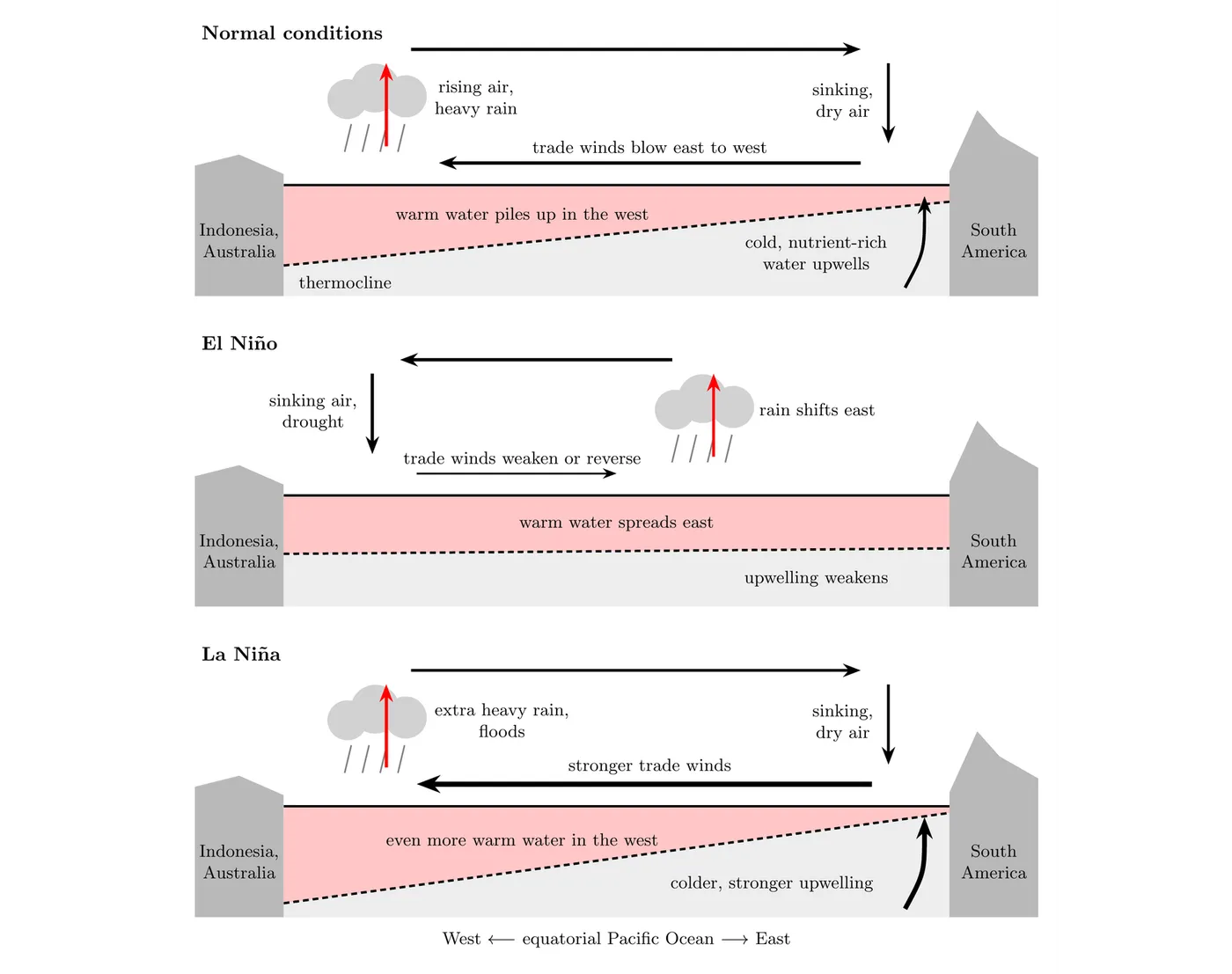
The focus for ENSO is the equatorial Pacific Ocean, the band along the equator from Indonesia and Australia in the west to South America in the east. Under normal conditions:
- Trade Winds: Blow from east to west.
- Water Shift: This pushes the warm surface water toward the west, toward Australia and Southeast Asia.
- Weather in the West: Warmer water means warmer air, more moisture, and higher precipitation in Southeast Asia.
- Upwelling in the East: Warm water moving away from the Americas pulls cool, nutrient-rich water up to the surface, creating productive fisheries.
- Pressure: A low-pressure system sits over the West (warm, rising air) and a high-pressure system sits over the Americas (sinking air), and that pressure difference keeps the east-to-west trade winds going.
- Thermocline: The boundary between the warm surface layer and the cold water below it. Normally it’s deep in the west, where warm water piles up, and shallow in the east, so upwelling near South America easily brings cold, nutrient-rich water to the surface.
- The Southern Oscillation: The seesaw in air pressure between the western Pacific (measured at Darwin, Australia) and the central Pacific (measured at Tahiti). When pressure rises in the west and falls in the east, the trade winds weaken and El Niño develops. That’s why the whole cycle is called the El Niño-Southern Oscillation (ENSO).
III. El Niño Conditions (The Warm Extreme)
El Niño is one extreme of the Southern Oscillation, bringing warmer, rainier conditions to South America.
El Niño Effects | Americas (East) | Asia / Australia (West) |
Trade Winds | Weaken, and in strong events can even reverse and blow west to east. This shifts weather and ocean currents globally. | |
Water Shift | Warm surface water shifts toward the Americas. | Experiences cooler than normal conditions. |
Weather | Warmer and much rainier, with a risk of flooding. Milder winters in North America. | Less rain, with a risk of drought conditions. |
Upwelling / Fisheries | Upwelling gets suppressed or shut down by the warm water mass. This hurts fishermen who rely on productive fisheries for food and income. | N/A |
Hurricanes / Monsoons | Weakens hurricane activity in the Atlantic, but strengthens hurricanes in the eastern Pacific. | Typically weakens monsoon activity in India and Southeast Asia. |
- How El Niño Starts: The trade winds weaken, so they stop holding the warm water in the west. The warm water sloshes back east along the equator, the thermocline in the east sinks deeper, and upwelling near South America brings up warm, nutrient-poor water instead of cold, nutrient-rich water. The rising, rainy air follows the warm water east.
- Example (Fisheries): During the 1972 to 1973 El Niño, combined with heavy overfishing, Peru’s anchoveta fishery (then the largest fishery in the world) collapsed.
- Example (Heat and Drought): The 2015 to 2016 El Niño, one of the strongest on record, heated tropical oceans enough to cause mass coral bleaching (including on Australia’s Great Barrier Reef in 2016), and it brought drought to parts of southern Africa and Southeast Asia.
- How Often: El Niño and La Niña come back every 2 to 7 years and usually last 9 to 12 months, with neutral years in between.
- How NOAA Decides: NOAA declares El Niño when the ocean surface in the central equatorial Pacific (the Niño 3.4 region) runs at least 0.5°C warmer than normal for several months in a row, and La Niña when it runs at least 0.5°C cooler. Since February 2026, NOAA measures this against the rest of the tropics (the Relative Oceanic Niño Index), so overall global warming isn’t mistaken for El Niño.
- As of October 2026: A strong El Niño is underway. NOAA’s 8 October 2026 update reported the Niño 3.4 region about 2°C warmer than normal, weakened trade winds, heavy rain shifted to the central and eastern Pacific, and drier than normal conditions over Indonesia. NOAA expected a strong to very strong El Niño to last through early 2027.
IV. La Niña Conditions (The Cold Extreme)
La Niña is driven by stronger than normal trade winds and brings cooler, drier conditions to South America.
La Niña Effects | Americas (East) | Asia / Australia (West) |
Trade Winds | Stronger, still blowing east to west. | N/A |
Water Shift | N/A | Warm surface water gets pushed back over to Australia and Southeast Asia. |
Weather | Cooler than normal and less rain. Can increase tornado severity in the US. | Even warmer and rainier than normal, with a risk of extreme flooding and more intense monsoon activity. |
Upwelling / Fisheries | Increased upwelling and especially productive fisheries. | N/A |
Hurricanes / Monsoons | Increases hurricane activity in the Atlantic. | N/A |
- How La Niña Works: Stronger trade winds push even more warm water west. The thermocline in the east rises even closer to the surface, so upwelling near South America brings up extra cold, nutrient-rich water, and the rising, rainy air stays far west over Indonesia and Australia.
- Example: The strong La Niña of 2010 to 2011 brought record floods to Queensland, Australia, and contributed to the severe 2011 droughts in Texas and East Africa.
V. Why ENSO Hits Different Places Differently
- Geography Sets Up ENSO: The Pacific is the widest ocean, so the trade winds blow across thousands of kilometers of open water along the equator. Land on both sides (Asia and Australia in the west, the Americas in the east) lets warm water pile up on one side while cold water upwells on the other. That’s why ENSO is a Pacific pattern.
- Opposite Effects on Opposite Sides: The rising, rainy air follows the warmest water. So El Niño makes Peru and Ecuador wetter and Indonesia and Australia drier, and La Niña does the reverse.
- Farther Away, Effects Travel through the Jet Stream: In a typical El Niño winter, the southern US is wetter and cooler than normal, while the northern US and Canada are warmer. La Niña usually brings the opposite, including a drier southern US.
- Hurricanes and Monsoons: El Niño strengthens the winds high over the Atlantic, which tear developing hurricanes apart, so Atlantic hurricane seasons are usually quieter. It also tends to weaken India’s summer monsoon. La Niña does the opposite.
Big picture
The El Niño Southern Oscillation is like a giant global bathtub of water sloshing back and forth across the Pacific. Under normal conditions, the trade winds constantly push the warm water to the west end of the tub, causing rain there and pulling cold water up at the east end near the Americas. During El Niño, the push stops and reverses, so the warm water surges back east, flooding the Americas while leaving the west end empty and dry. During La Niña, the push is aggressively strong, forcing even more warm water and rain to the far west end of the tub.