

1.2 - The African Continent: A Varied Landscape
Africa's Geography
Africa is the second-largest continent on the planet, and it's a lot more geographically diverse than people often give it credit for. Instead of one single landscape, it's made up of five major climate zones:
- Desert, like the Sahara
- Semiarid, like the Sahel
- Savannah grasslands
- Tropical rainforests
- Mediterranean zone
The continent is also framed by major bodies of water: the Red Sea, the Mediterranean Sea, the Atlantic Ocean, and the Indian Ocean. Inside the continent itself, five major rivers, the Niger, Congo, Zambezi, Orange, and Nile, connect different regions to one another, acting like highways through the interior.
How Geography Shaped Settlement and Trade
Africa's landscape wasn't just scenery. It actively shaped where people settled and how they traded with each other, both within the continent and beyond it.
Because the Red Sea, Mediterranean Sea, and Indian Ocean all sit close to the African coast, early societies were able to form near these waters and build connections that reached well beyond Africa itself. This is part of why early Africa was globally connected far earlier than a lot of people assume.
For example, the Nile and the Red Sea connected Egypt, Nubia, and Aksum to the Mediterranean world, Arabia, and India (Topic 1.4), and the Indian Ocean linked the East African coast to Arabia, Persia, India, and China (Topic 1.8).
Within the continent, population centers grew up specifically in the Sahel and the savannah grasslands, and there were three main reasons for that:
- Water routes: Major waterways made it easier to move people and goods around through trade.
- Example: the Niger River curves north to the edge of the Sahara near Timbuktu. Each year it floods a wide area in today's Mali (the Inland Niger Delta), leaving rich farmland, and boats carried goods up and down the river. That's a big reason trading cities like Djenné and Timbuktu grew along it (Topic 1.5).
- Fertile land: Good soil supported growing agriculture and let people domesticate animals.
- A trade bridge: The Sahel and savannah grasslands sat right between the Sahara to the north and the tropical regions to the south, making them a natural connector for trade between the two.
Climate variation across the continent also meant different regions specialized in different goods:
- In the desert and semiarid areas, herders were often nomadic, moving around in search of food and water, and some traded salt.
- In the Sahel, people traded livestock.
- In the savannah grasslands, people grew grain crops.
- In the tropical rainforests, people cultivated kola trees and yams, and traded gold.
So depending on where you were on the continent, your economy and way of life looked pretty different, all shaped by climate.
These differences are what made trade worth it. The Sahara had salt mines but no gold, while lands farther south, including the forest zone, had gold but little salt. People in hot climates need salt to stay healthy, and it also preserves food, so salt was valuable. Salt moved south, gold moved north, and towns in the Sahel and savannah grew as the meeting points, fed by Sahel livestock and savannah grain.
Required Sources
Map Showing the Major Climate Regions of Africa
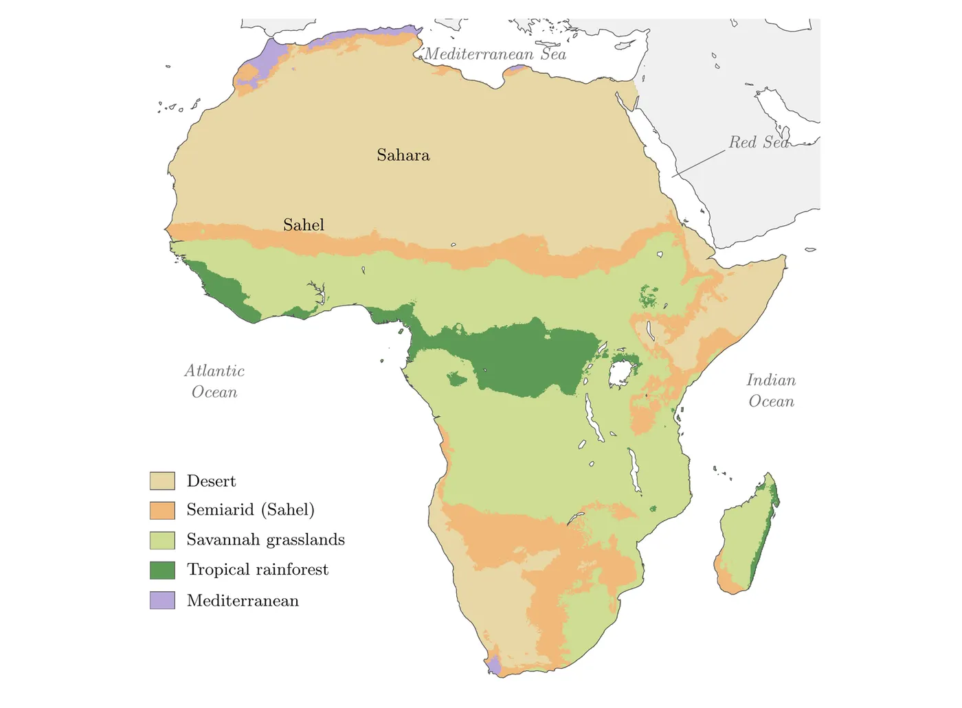
This map is basically the visual backbone of the whole topic. It shows exactly how these climate zones are laid out across the continent, desert up in the Sahara region, semiarid just below it in the Sahel, then grasslands, tropical rainforest, and the Mediterranean zone along the northern coast. Seeing it laid out spatially makes it a lot easier to understand why certain trade goods and settlement patterns lined up where they did. The zones aren't randomly scattered, they follow a logical band pattern across the continent, and that pattern directly explains why, say, salt trading happened in the desert while gold and yams came out of the rainforest belt further south.
Two things to notice on the map. First, the pattern repeats in reverse south of the rainforest: savannah again, then semiarid land, then desert in the southwest, and a small Mediterranean zone at the southern tip. Second, the Sahel is a thin band where the desert meets the grasslands, which is why it worked so well as a trade bridge between the Sahara and the lands to the south.