

1.8 - Cultural and Trade Networks in South and East Africa
Great Zimbabwe and Its Stone Architecture
The Kingdom of Zimbabwe, along with its capital city of the same name, Great Zimbabwe, flourished in Southern Africa from the twelfth to the fifteenth century. It was connected to the broader trade network running along the Swahili Coast, and its people, the Shona, built significant wealth through gold, ivory, and cattle.
What Great Zimbabwe is really remembered for today is its massive stone architecture. These weren't just impressive structures for their own sake, they served real, practical purposes: military defense and a hub for long-distance trade. Within the site, the Great Enclosure functioned as a center for religious and administrative activity, while the conical tower is believed to have served as a granary, a place for storing food.
The walls were built from cut granite blocks stacked carefully without any mortar, and some stand more than 30 feet high. The name Zimbabwe likely comes from a Shona phrase meaning "houses of stone." Archaeologists have also found Chinese porcelain, Persian pottery, and glass beads at the site, proof of how far its trade reached through the Swahili Coast.
These stone ruins still matter today as a powerful symbol. They stand as physical proof of the prominence, independence, and agricultural sophistication of the Shona kings and early African societies like the Kingdom of Zimbabwe, direct evidence against any claim that early African societies lacked organization or achievement.
That symbol mattered because, in the late 1800s and early 1900s, white colonial writers claimed Africans couldn't have built Great Zimbabwe and credited it to outsiders. Archaeologists in the early 1900s showed it was built by the ancestors of the Shona. When the former colony of Rhodesia won independence in 1980, it took the name Zimbabwe from the site.
The Swahili Coast City-States
The Swahili Coast gets its name from sawahil, the Arabic word for coasts, and it stretches all the way from Somalia down to Mozambique. Its location made it a natural connector, linking Africa's interior to trading communities from Arabia, Persia, India, and even China.
Geography made this trade possible. The monsoon winds over the Indian Ocean blow from the northeast for part of the year and from the southwest for the other part, so ships from Arabia and India could sail to the East African coast in one season and sail home in the next. Swahili merchants sold gold (from Great Zimbabwe, shipped through Sofala), ivory, and other goods from the interior, and bought cloth, beads, and porcelain from Asia. Kilwa grew so rich that the traveler Ibn Battuta, who visited in 1331, called it one of the most beautiful and well-built towns in the world.
Between the eleventh and fifteenth centuries, the many city-states along this coast weren't politically unified, but they were culturally unified. They shared a common language, Swahili, which is a Bantu-based lingua franca, and a common religion, Islam. That shared culture helped these separate city-states function as a connected trading network rather than isolated settlements.
Swahili itself shows this blend: its grammar is Bantu, but it borrowed many words from Arabic. Islam spread along the coast through Arab and Persian merchants who settled in the towns and married into local families, and towns like Kilwa built mosques and houses out of coral stone.
Eventually, the wealth and success of these trading states drew unwanted attention. In the sixteenth century, the Portuguese invaded several major city-states and established their own settlements, specifically to seize control of the lucrative Indian Ocean trade.
Politics made the coast easy to attack. The city-states were independent and often rivals, so they never united against the Portuguese, and some, like Malindi, even sided with them. After Vasco da Gama reached the coast in 1498, Portuguese fleets attacked Kilwa and Mombasa in 1505. Portuguese efforts to control and tax the trade disrupted the old networks, and many of the city-states declined.
Required Sources
Photographs of Great Zimbabwe's Walls and Stone Enclosures, Twelfth to Fifteenth Century
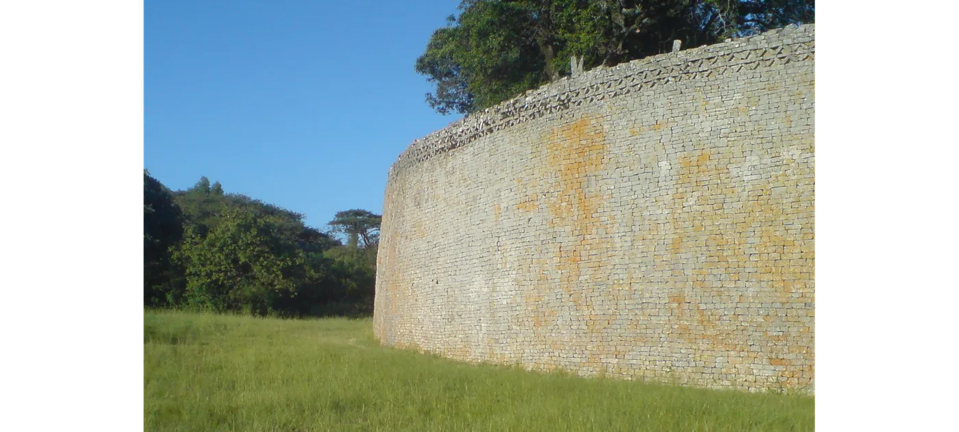
These photographs let you actually see the scale and craftsmanship of Great Zimbabwe's construction firsthand. The stonework shown here is what supported all three of the site's major functions described above: defense, trade, and religious and administrative life. Seeing the walls in person, so to speak, makes it much easier to understand why this architecture became such a lasting symbol of Shona achievement and autonomy.
The photo above shows the curving outer wall of the Great Enclosure. Notice the even rows of granite blocks with no mortar, and the zigzag (chevron) pattern along the top, a sign that the builders cared about decoration as well as strength.
More photographs of Great Zimbabwe: the conical tower and the narrow passages
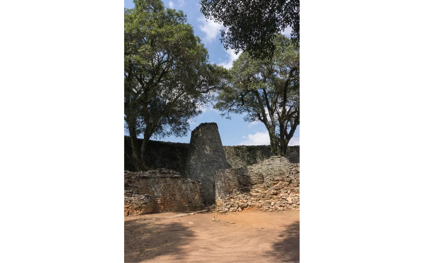
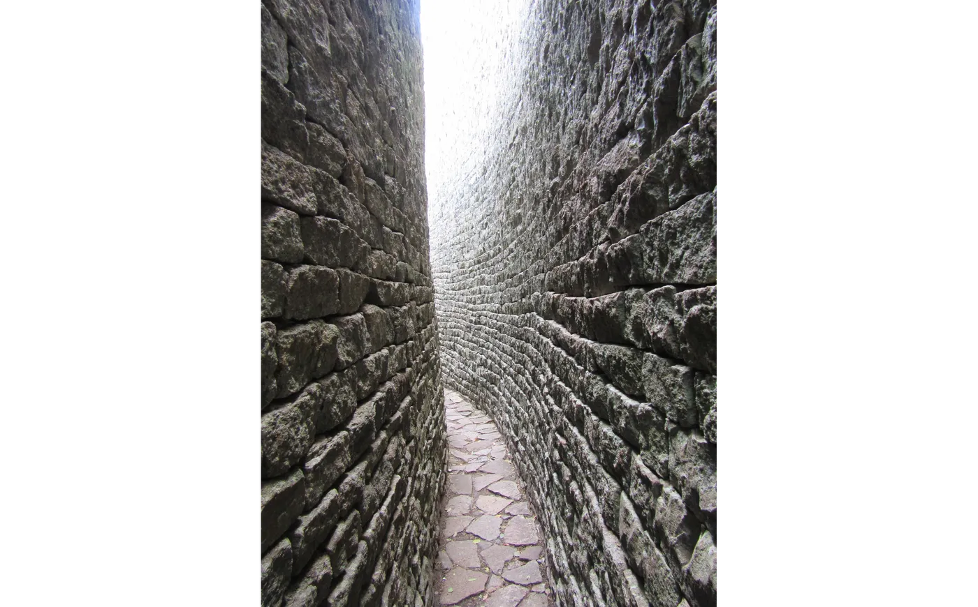
Inside the Great Enclosure stands the conical tower, a solid stone tower about 30 feet tall with no doors or rooms inside. It couldn't have held grain itself, so many scholars read it as a symbol of a granary, standing for the ruler's role in storing and sharing grain. The site also has narrow passages squeezed between high stone walls, like the long passage inside the Great Enclosure that leads toward the tower. Passages like these let only a few people through at a time, which helped control who could reach the most important parts of the site and fits the walls' role in defense.
Map Showing Indian Ocean Trade Routes from the Swahili Coast
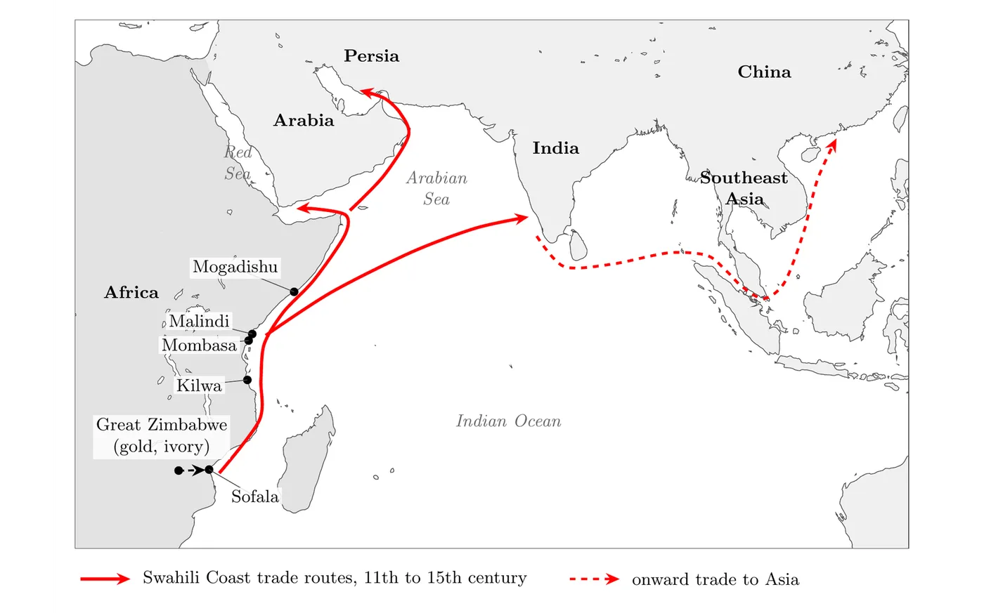
This map lays out exactly how far the Swahili Coast's trade network actually reached. Tracing the routes from cities like Mogadishu, Malindi, Mombasa, Kilwa, and Sofala out across the Indian Ocean shows why this coastline became such a valuable and contested trading zone, and why, eventually, the Portuguese saw enough value in it to invade. The map basically turns the abstract idea of "Indian Ocean trade" into a concrete picture of just how interconnected East Africa was with the rest of the ancient trading world.